
Table of Contents
- Key Takeaways
- Introduction: A Shifting Landscape
- The State of Air Quality in the Valley
- What to Expect from Large-Scale Land Transitions
- Maintaining Cover and Targeting Smart Investment
- Recommendations
- Conclusion
- Notes and References
- Authors and Acknowledgments
- PPIC Board of Directors
- PPIC Water Policy Center Advisory Council
- Copyright
Key Takeaways
The Sustainable Groundwater Management Act (SGMA) requires groundwater users to bring their basins into balance over the next two decades. In the San Joaquin Valley, this will mean taking more than 500,000 acres of agricultural land out of intensive irrigated production. Among other issues, this could potentially lead to air quality impacts if the lands become new sources of dust, especially windblown dust, which can have numerous negative short- and long-term health and environmental impacts. In addition, the changing climate may exacerbate risks as warmer temperatures can dry out soils and increase dust emissions. The overall air quality impact of transitioning agricultural land to new uses is nuanced, but proactive management can help to identify high-risk areas and at-risk communities, and direct effort and funding to the most cost-effective interventions.
- The valley experienced reductions in particulate matter concentrations throughout the early 2000s, but these concentrations have since increased again—in part due to wildfire smoke. Landscape-based emissions from agriculture and windblown dust may grow with increased fallowing and warmer, drier climatic conditions, and they are likely to impact low-income, rural communities first and foremost. Proactive management to reduce dust emissions can deliver large benefits.
- Agricultural operations and wind erosion are two of the largest sources of dust in the valley. The net effect of transitioning land from active agriculture to fallow appears to depend on the crop being grown, the level of disturbance on lands following their idling, and the time of year. Risks can be minimized by certain on-farm practices and the up-front identification of priority mitigation areas.
- Maintaining vegetative cover is one of the easiest and most cost-effective ways to reign in dust emissions from idled landscapes. Establishing this cover without irrigation, however, can be a challenge. Water-limited farming, with a small amount of irrigation to establish cover, could provide one avenue forward. Grazing is often a part of successful vegetation management and can provide economic returns from these lands, but if managed poorly it can disturb soils and increase dust risk. Coordinated management of these lands to establish long-term vegetative cover—or other measures to control dust—will be paramount.
- Experiences elsewhere in the West provide insights about how best to administer, monitor, and structure dedicated dust control projects on transitioning and fallowed lands. One common theme is the importance of sustained, reliable funding. Local funding through groundwater sustainability agencies, state funding through the regional air district, and federal funding through existing conservation and environmental incentive programs are promising options for sustaining proactive dust management.
Introduction: A Shifting Landscape
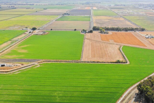
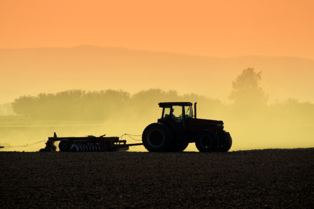
The Sustainable Groundwater Management Act (SGMA) will lead to extensive changes in groundwater availability in the San Joaquin Valley, and accordingly in how land is used and managed. Previous PPIC work has laid out the scale of the challenge: between 500,000 and 1 million acres could come out of regular irrigated agricultural production by 2040 (Hanak et al. 2019). Achieving groundwater sustainability will bring long-term benefits to the region, but in the near term, bringing large tracts of agricultural land out of irrigated production can affect regional economic activity, weed dispersal, and air quality if these lands are not managed carefully.
The San Joaquin Valley already faces ongoing air quality problems. It is a major transportation thoroughfare for the state and has historically been prone to particulate matter and dust problems, often worsened by high-wind events. As an enclosed valley, it also has a tendency to collect and retain pollutants for prolonged periods. Many of the valley’s metropolitan areas rank among the most polluted in the nation by a number of air quality metrics (EPA 2019). Rural areas face similar challenges, and negative human health impacts are pervasive—one estimate puts the valley-wide economic costs at $3 billion per year (Hall and Brajer 2006).
Local stakeholders and regulators have expressed well-founded concerns that uncoordinated land use conversion under SGMA could exacerbate these problems by generating additional sources of landscape-based particulates, or dust. There are some historical cases of agricultural land conversions causing air quality issues across the US—not least of all the Dust Bowl that devastated the Great Plains in the 1930s—and the San Joaquin’s soils and climate lend themselves to similar conditions. While the valley saw important reductions in particulate concentrations throughout the early 2000s, these have been partially reversed recently (in part by increased wildfire activity), and looming transitions of land out of regular irrigated production present additional risks.
Coordination is paramount for reducing the costs of SGMA implementation, and collaborative work to control dust is one piece of that. A fragmented patchwork of lands removed from irrigated production can heighten dust impacts on neighbors and make it harder to implement cost-effective on-farm interventions. Lands not managed properly, or managed for sometimes-competing purposes such as weed control, may lead to increased dust emissions and public health problems.
Approaches to effectively manage these impacts and deftly navigate trade-offs will require effort from multiple parties. On the front line is the San Joaquin Valley Air Pollution Control District (SJVAPCD), which disburses funding to support pollution mitigation, promulgates and enforces regulations, identifies emerging threats, and communicates with the public. In addition, the California Air Resources Board (CARB) and Department of Conservation (DOC), alongside the federal Natural Resources Conservation Service (NRCS), can direct funding to support on-farm interventions and pilot projects, and local entities like SGMA’s groundwater sustainability agencies (GSAs) will help to determine which lands are fallowed. These parties all can play a role in developing sensible mitigation programs and sustained funding streams; broader efforts at improved monitoring of air quality in the valley can also deliver significant value.
In this report, we review the evidence on the potential impacts of transitioning large tracts out of irrigated production within the valley and explore options for effect management. We also summarize our related discussions with stakeholders and land managers. Our study includes lessons learned from workshops and interviews with experts and local stakeholders, a review of the relevant literature, novel data analysis, and several case studies from California and the West. Two technical appendices summarize details of the analyses (Appendix A) as well as the suite of on-farm dust mitigation measures that may be available for land management (Appendix B). This report is part of a larger effort by the PPIC Water Policy Center and numerous partners to understand how land transitions in the valley can best be managed, including a companion report on opportunities for water-limited agriculture (Peterson et al. 2022). Further reports on the technical, economic, environmental, and institutional considerations for management will be released in coming months.
The State of Air Quality in the Valley
Historically, valley populations have faced challenges with a number of different air pollutants, locally and regionally. The regional air district has been successful in addressing some of these by effectively identifying and controlling emissions sources. For example, the valley now meets federal standards for harmful pollutants such as nitrogen dioxide, sulfur dioxide, carbon monoxide, and lead. Although progress has also been made in reducing other pollutant concentrations, several still remain above federal and/or state standards.
In particular, according to the US Environmental Protection Agency (EPA), valley communities broadly and regularly do not meet national standards for ozone and fine particulates. Ozone largely originates from reactions between certain chemical compounds—mainly emitted from combustion and oil and gas wells—that occur when they mix in the atmosphere and are exposed to sunlight. A number of sources, reflecting both natural physical processes and human activity, generate particulate matter. This discussion focuses primarily on these particulate matter challenges, and specifically on dust that is mobilized from the landscape.
Dust in Context
In national rankings of peak particulate matter concentrations, valley cities typically place very high for both smaller (PM2.5, less than 2.5 microns in diameter) and larger particulates (PM10, less than 10 microns). In 2019, four of the top ten communities for both size categories were in the valley (EPA 2019). Rates of asthma and similar respiratory illnesses are elevated here, in part for this reason. Particulate matter concentrations typically peak during the winter, when weather conditions (most notably temperature inversions) lend themselves to stagnant air and the accumulation of pollutants for days or weeks at a time. As noted above, the valley broadly does not meet federal annual average PM2.5 standards; while it meets the federal standard for PM10, some local areas do not meet state standards (Figure 1).
Major sources of finer particulates include automobile emissions, combustion of diesel and other fuel sources, wildfire smoke, and to some extent windblown, or fugitive, dust. Landscape emissions, such as dust mobilized by wind, tillage, crop harvest, and vehicle traffic on unpaved roads, are a more prominent source of coarser particulates. Box 1 provides additional detail on the particulates that end up in the air and their potential human health and other economic impacts.
Although state and local agencies maintain numerous monitoring sites throughout the valley, only a few have tracked particulate matter concentrations over the long term (more than five or ten years), making it a challenge to understand how risks vary over time and space. Despite the valley’s ongoing air quality challenges, the data suggest that PM10 concentrations fell somewhat during the early 2000s (Figure 1). This was followed, however, by a recent uptick, with today’s concentrations in some cases reaching pre-downturn levels.
Following a period of decline, coarse particulate concentrations have risen in recent years
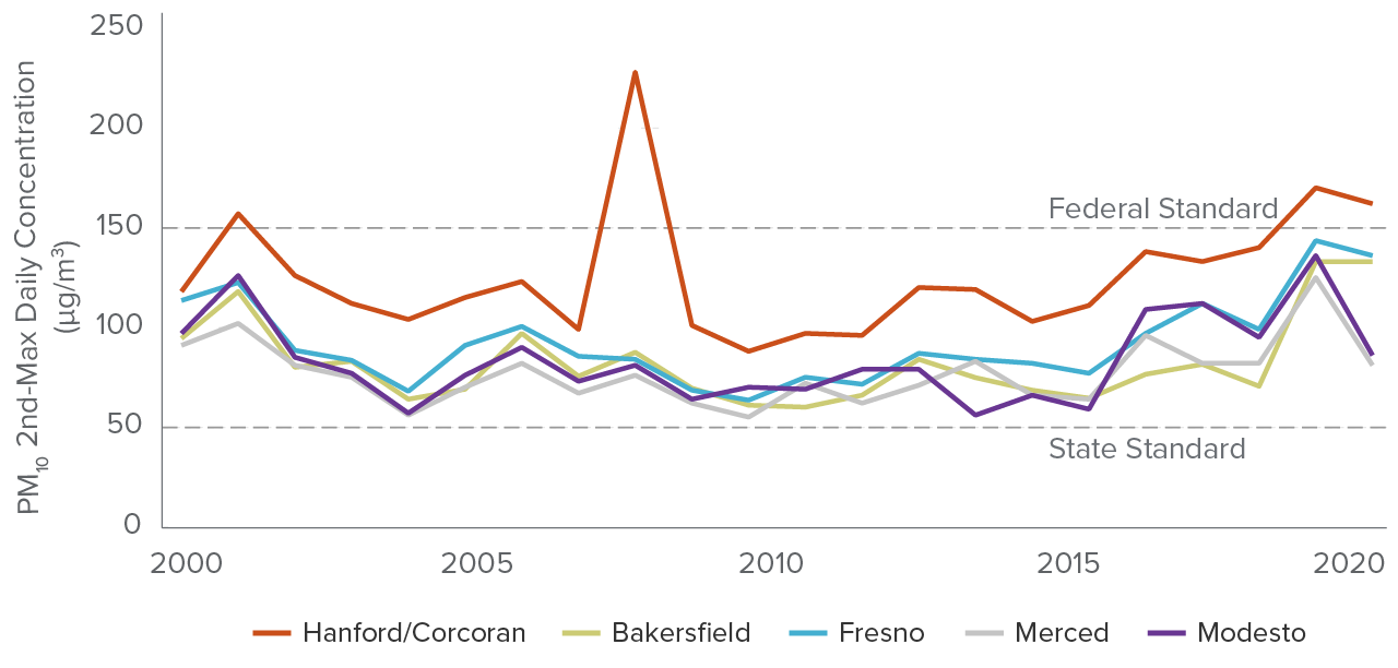
SOURCE: Developed by the PPIC Water Policy Center using data from the US Environmental Protection Agency.
NOTE: Figure plots the annual second-highest daily PM10 concentrations (in μg/m3) for valley monitoring sites for years 2000–19. The 2008 outlier in Hanford/Corcoran receives no explanation in official documentation but likely reflects a local building fire. Federal and state standards reflect the thresholds active in 2019.
Because it is difficult to establish the specific sources of particulates in the air, it can be challenging to ascertain precisely how much different sources contributed to these reductions and increases. However, air district reports indicate initial reductions were not driven by reductions in economic or transportation activity (SJVAPCD 2007). Indeed, population, GDP, and vehicle traffic, as measured by vehicle-miles traveled, increased substantially in the early 2000s. Instead, ongoing efforts to constrain emissions from sources like farming operations—alongside improving transportation and engine technology—were more likely drivers.
In particular, the Conservation Management Practices (CMP) Program (also known as Rule 4550) adopted by the regional air district in 2004 was effective in reducing particulate emissions from agricultural sites. The rule lays out a set of on-farm conservation practices that landowners can choose from to control dust cost-effectively on their lands. Intended practices are approved by the district, and the district has worked with landowners and other implementation agencies (such as NRCS) to support implementation and compliance. The program is credited with reducing PM10 emissions by approximately 35 tons per day and enabling valley attainment of federal standards (Klassen 2022).
Subsequent growth in PM10 concentrations over the past decade is likely related to increases in wildfire smoke and shifts in crop choice that have resulted in some additional on-farm emissions (see discussion of orchard crops below). In 2020, wildfires were estimated to have released over 1.3 million tons of PM10 statewide in California (CARB 2021c), a substantial portion of overall emissions. The valley is uniquely positioned as a sink for many such emissions originating from Sierra Nevada forests, and these emissions are likely to reside in the valley for some time, even after wildfires subside. In contrast, windblown dust emissions have largely remained stable, according to emissions inventories (CARB 2021a).
Increasing emissions from wildfire could make it difficult to maintain progress on air quality, and a pronounced decline in irrigated acreage may further complicate the matter if lands are not actively managed to limit dust. In addition, one important risk factor affecting windblown dust in the valley is the changing climate: as warmer temperatures increase aridity and dry out soils, particles of dust will become lighter and easier for the wind to mobilize. Together, these processes represent a set of important risks for valley air quality and highlight the importance of understanding and controlling landscape-based emissions moving forward.
Landscape Sources of Dust
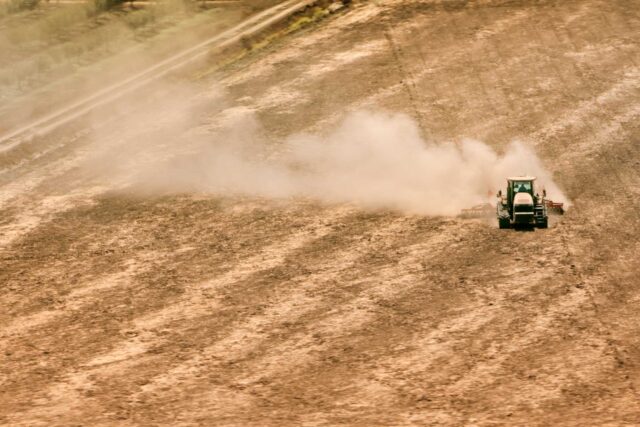
The bulk of PM10 emissions arises from the landscape. In our discussion of landscape-based PM sources, we include agricultural operations, paved and unpaved roads, and fugitive windblown dust. Figure 2 summarizes the relative contribution of these sources within the San Joaquin Valley, including a few related components of agricultural operations that generate fewer emissions (e.g., food processing and burning crop residues). With the scale of land transitions expected under SGMA, two major components are likely to shift: farming operations and fugitive dust. Dust emissions from farming operations are largely driven by direct human disturbance of the landscape, including tillage, harvest, off-road vehicle traffic, and other on-farm activities. While windblown dust results from the natural process of winds mobilizing particles from the landscape and suspending them in the air, soils that are exposed and disturbed by humans are more likely to produce dust.
There is historical precedent for large-scale dust storms in the San Joaquin Valley. Two events stand out, and both occurred during severe droughts. In 1991, an extreme windblown dust event caused property damage, low visibility, and ultimately a highway accident that killed over a dozen people (Pauley et al. 1996). Almost fifteen years earlier, 1977 saw one of the state’s worst dust storms: record-high wind events in the valley produced storms that led to extensive property damage, an outbreak of Valley fever cases, and other impacts (Lindsey 2019). In both cases, extreme drought conditions—with extended hot, dry weather; low snowpack; and low surface water deliveries to farms—exacerbated dust mobilization. Increasingly arid conditions under a changing climate may increase the risk of similar episodes in the future.
Dust from the landscape contains a mix of particle sizes: depending on soil and atmospheric conditions, perhaps half of these particles may be PM10, with 10 to 20 percent of those being fine particulate matter (PM2.5) (Cowherd 2006; Pace 2005). Fine and coarse particulates have different health effects, and they also travel different distances before settling; although even large particles can travel miles and stay suspended for days, smaller particles will generally travel farther and thus be more likely to encounter communities and ultimately cause human health impacts when stirred up by humans or the wind.
Rural exposure and the seasonality of dust generation
Landscape-based emissions originate mainly in rural areas from farms and undeveloped tracts of land. Since a large share of these emissions consists of larger particles that are less likely to travel long distances in the air, rural communities are likely to face greater risk of exposure and warrant specific consideration in evaluating the potential impacts of SGMA land transitions.
Long-term monitoring sites in the valley document particulate matter concentrations in relatively more urban areas such as Fresno and Bakersfield, and unfortunately, the pollution profiles in rural and urban areas can vary significantly (Schauer and Cass 2000). Indeed, PM10 concentrations at the Hanford/Corcoran site, which is located in a more rural area than the other sites shown in Figure 1, are uniformly higher, possibly in part due to the influence of local dust sources. At this time, broader monitoring of air quality (including particulates) in rural areas is not common and represents a knowledge gap in our ability to understand the likely impacts of land transitions. One reason rural monitoring is not more widespread is that establishing new monitoring stations is expensive; any potential expansion of monitoring in rural areas needs to consider carefully where new investments can generate greatest value.
Dust emissions from landscape sources vary throughout the year, with most produced during the summer, according to inventories provided by CARB (Figure 2). Spring and fall see many more high-wind events that drive fugitive dust, and harvest activities during late summer and fall expand emissions from farming. These events can drive concentrations and exposure to PM10 in rural areas. Regional air quality regulators focus some efforts on managing emissions during critical periods. For example, the nut harvester replacement program managed by the SJVAPCD, discussed later in this report, targets emissions specifically during harvest.
Most PM10 from the landscape is generated in the summer
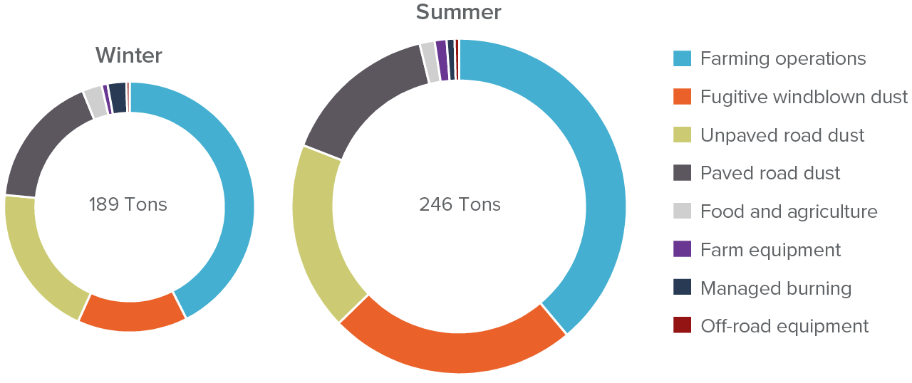
SOURCE: Developed by the authors using information from the California Air Resources Board’s (CARB) California Emissions Projection Analysis Model (CEPAM; v1.05).
NOTES: Estimated daily production of particulate matter less than 10 microns in diameter is presented by season for 2020. Only landscape sources are included. Graphs are scaled by daily emissions. Winter includes October–March, and summer April–September. Sectoral breakdowns are by broad source category. “Farming Operations” includes tilling, harvest, and a wide variety of other agricultural operations; “Farm Equipment” includes emissions from combustion, etc. “Food and Agriculture,” in contrast, reflects downstream processing. “Fugitive Dust” accounts for fugitive dust mobilized by wind (not by vehicle traffic).
In addition to the health impacts of dust exposure described in Box 1, dust that originates from valley landscapes has unique characteristics that can lead to additional human health complications. For example, a fungal organism known as Coccidioides is endemic to the San Joaquin Valley and, if inhaled, can cause Valley fever (Box 2). Furthermore, as discussed in Box 3, some pesticides used in agriculture may persist in soils and be mobilized in dust. These chemical and biological components form a mixture of particles that can arise from the valley’s landscapes and present additional complications, and unknowns, for planning and management.
What to Expect from Large-Scale Land Transitions
In some respects, San Joaquin Valley communities are likely to face air quality challenges and risks similar to those experienced in other areas of the West that have undergone significant land transitions. Yet in other ways, the problems will be unique due to the valley’s development layout, crop mix, and prevailing agricultural practices. In this section, we discuss several land transition cases from elsewhere in California and the West, including lessons learned for effective mitigation strategies and program design. We also present the results of two analyses using data from the San Joaquin. One explores the differences between emissions from agricultural landscapes and other fallowed or minimally managed land, in order to understand what the net effect of transitioning land might be. The second considers which rural areas might be most susceptible to these changes.
Lessons from Other Land Transitions
Our case studies include two earlier experiences with land transitions in California—in the Imperial and Antelope Valleys—and an example from eastern Washington State.
Imperial Irrigation District fallowing program
In 2003, the Imperial Irrigation District (IID) initiated a fallowing program that would remove land from production over 15 years in order to free up water for a long-term transfer and local environmental mitigation efforts. After starting small, by 2013 the program encompassed enough land to make available up to 150,000 acre-feet of water annually for transfer—typically between 30,000 and 40,000 acres (IID 2016). Imperial Valley, like the San Joaquin, is an area with high particulate matter concentrations that have well-documented, widespread health impacts. In concert with the regional air district, IID devised a process for addressing potential dust emissions from these lands through the compensated adoption of best practices; these practices included maintenance of vegetative cover on fallowed lands and the use of chemical soil stabilizers, among others. Farmers who applied for the fallowing program could simultaneously select a dust management approach and receive funding to implement it.
Two key lessons from the IID case stand out. First, it is important to have a dedicated funding source. IID was able to tap resources available under the Joint Powers Authority that was established to fund broader environmental mitigation at the Salton Sea; this JPA was funded in part by IID, but also by other parties to the transfer agreement (i.e., the water buyers). Without this funding, making water available for the transfer program would have been more difficult, or come with greater dust risks. Second, the fallowing program necessitated the development of a dedicated monitoring program. Administrators reported that in some cases landowners would apply to fallow and maintain stubble to control dust, yet then either attempt to apply water for stubble maintenance or other dust suppression (negating some water conservation benefits of fallowing) or remove the stubble (negating dust mitigation benefits). The scale of the program run by IID provided some advantages in bearing these monitoring costs; valley subbasins or GSAs that see similar levels of fallowing might productively set up similar programs. But where groundwater management lacks coordination and lands exit production haphazardly as irrigators lose reliable access to water, such monitoring may be more difficult to coordinate and fund.
Antelope Valley dust mitigation and monitoring program
The second case is the Antelope Valley, an area of eastern Kern and northern Los Angeles counties where agricultural land retirement was followed by a dedicated dust mitigation and monitoring program. Retirement of mostly marginal agricultural lands (and subsequent grazing of these lands) throughout the 1980s led to severe fugitive dust and soil erosion issues. Several thousand acres of highly disturbed lands produced enough migrating dust to fill swimming pools, cause roadway accidents, and sandblast physical infrastructure during high-wind events. A “Dust Busters” Task Force was convened to work with the regional air district to assess the problem and develop solutions.
The program aimed to re-establish vegetation (some native) as a dust management intervention—and to assess its effectiveness. Researchers learned that lands that were previously farmed intensively contained so much legacy nitrogen that native shrub varieties were often easily out-competed by weeds and weed-like plants—an issue that is likely to arise in the San Joaquin as well. Despite this challenge, the program was largely successful, and vegetative cover was established on much of the intended land. However, its success was driven in large part by fortuitous precipitation conditions (Slayback et al. 1995). Previous efforts to establish similar plant species had failed in drier times, highlighting the risky nature of revegetation programs in arid environments. Finally, stakeholders we spoke with also cited access to dedicated and ample funding as a key enabler: the program received funding from Los Angeles County as well as the federal government, with NRCS providing the bulk (over 85%) via an Emergency Watershed Protection Grant.
Eastern Washington conservation tillage program
A final case, from eastern Washington, highlights the value of a specific on-farm intervention for controlling dust in arid environments. In contrast to the California examples, these lands were typically not taken out of production, but rather were part of rotational fallowing systems common on millions of acres of dry-farmed lands in the region.
A multiyear pilot and assessment project, the Columbia Plateau PM10 Project, began in 1992: it aimed to identify and develop new technologies to control soil erosion and dust generation on predominately dry-farmed cropland (mostly wheat) and provide technical implementation support so that farmers could adopt these technologies and operate profitably. Initial funding from the US EPA and Washington State Department of Ecology was later supplemented by sustained federal funding through a special grant from Congress that lasted through 2011.
Results from the project emphasize the importance of maintaining surface cover and soil roughness. One example is the development of new conservation tillage practices. Conventional tillage systems were widely used in the region to control weeds and prepare the land for subsequent planting; the conservation tillage systems designed for this intervention use specialized equipment to reduce surface disturbance, and in this case successfully lowered PM10 indicators by roughly 70 percent (Bista et al. 2017).
Implications for the San Joaquin Valley
The air quality challenges from land transitions in the San Joaquin Valley will be different from these examples. First, with 500,000 or more acres coming out of production, the scale of the land-use shift exceeds those seen in the Antelope Valley and IID cases (several thousand to tens of thousands of acres, respectively). Nonetheless, the valley has already seen large expanses of irrigated land come out of production, such as the roughly 360,000 acres that were not irrigated in 2015 during the last drought (Howitt et al. 2015). More recently, Westlands Water District saw over 200,000 acres fallowed in 2021 and has been actively managing approximately 100,000 acres of non-irrigable, drainage-impaired land for years (Westlands Water District 2022; Hiltzik 2015). Second, the San Joaquin Valley has a denser set of rural settlements than these other case sites, which could result in more human exposure to dust. Finally, and not least of all, alternative productive uses for these lands (e.g., solar, habitat, and water-limited cropping) may present themselves, with their own advantages and disadvantages when it comes to local air quality.
Taking these differences together, it becomes clear that both organizing effective monitoring and incentive programs and finding reliable funding resources will be paramount. Although the state has demonstrated some interest in funding air quality management (for example, through a nut harvester replacement program described below), additional efforts will be needed. Local GSAs can also begin the organization and administration of some of these programs, perhaps in concert with local partners like the SJVAPCD. Some of these activities have high up-front costs, such as establishment of additional organizing bodies to monitor and assess program success, while others consist of mostly recurring expenses—particularly the ongoing maintenance for on-farm interventions such as conservation tillage, cover cropping, mulching, surface roughening, etc. (See Appendix B for more detail.)
The scale of the transition underscores the importance of funding: depending on new land use opportunities, perhaps 500,000 or more acres of formerly irrigated lands may require ongoing maintenance to manage dust. Per-acre cost estimates from Appendix B range widely—from a few dollars per acre to several thousand (See Box 4 for a summary). Taking a restricted range of approximately $25 per acre for low-cost treatments (which may better reflect average costs for smaller projects) to $160 per acre for high-cost treatments, annual maintenance costs for this transitional acreage could range from approximately $12–80 million. It is likely, however, that not all 500,000 acres would require treatment every year, so actual costs could be lower. There is precedent for state funding of this magnitude to support important, large-scale shifts in agricultural practices that promote air quality: the decision to phase out agricultural burning in the valley was accompanied by an initial allocation of approximately $178 million in state funds to help farmers find alternatives in the near term (SJVAPCD 2021). A similar funding program could make an important contribution to dust mitigation efforts in early years, even if it is not maintained over the long term.
In addition to funding, effective communication about the available on-farm options for controlling dust and the establishment of a regulatory baseline of what dust control measures are necessary will be important. In the IID case, for example, certain actions were required of the water trading parties to mitigate environmental impacts, which helped to scope and structure the goals of the dust mitigation program. In the San Joaquin Valley, the ongoing update of the regional air district’s CMP Program, described in more detail later in the report, presents an opportunity to further align these baseline on-farm activities with the upcoming challenges of large-scale land transitions.
Land Use Type, Seasonality, and Likely Transition Impacts
Along with dust from paved and unpaved roads, the two largest sources of PM10 in the valley are farming operations and fugitive dust (Figure 2). Fugitive dust arises primarily from exposed soils—such as tilled fallow—and the disturbance of landscapes through activities like grazing. Depending on the crop that will be fallowed, it is not clear that reducing irrigated acreage will always increase dust emissions—some farming operations may contribute more dust, or dust at different times, than uncropped landscapes.
In this section, we present an exploratory analysis associating local particulate matter concentrations with existing agricultural land use types—including various crops and fallowed land. These results can shed light on the potential impact that moving from one land cover to another could have on local dust concentrations. The estimates are based on land cover observed and reported by the US Department of Agriculture (USDA), Land IQ, and the California Department of Water Resources (DWR) for years 2010–16, and similar geospatial information on particulate matter concentrations in rural areas over the same timeframe from NASA. We also control for wildfire activity using data from Cal Fire.
Although rural air quality monitoring is limited within the valley, some recent advances in satellite-based observational methods have allowed researchers to combine monitor and satellite data for estimation of particulate concentrations in areas that lack local monitoring. We use these estimates to undertake the analysis but note that they are only available for PM2.5 and not PM10. A few important caveats are in order: first, dust is predominately made up of coarse particulate matter, so we capture here pollutants that are only a small portion of likely landscape emissions. Second, satellite-based methods have limitations in capturing local pollutant variation, possibly exacerbated by the complex mix of aerosols that occur in the valley. Finally, we measure local concentrations but not emissions, so conclusions regarding changes in emissions from land transitions rely on our application of statistical techniques to address other potential sources of local particulates. Appendix A provides details on the analysis and the relationships between PM2.5 and PM10 concentrations in these areas.
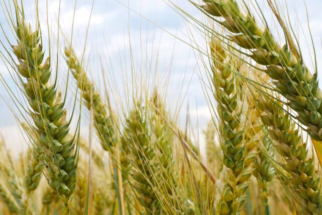
We consider three irrigated cropland types in the analysis: annual crops, almonds, and other orchard crops. Among tree crops, almonds have been identified as especially relevant for local dust emissions due to how they are harvested: they are typically shaken from tree limbs onto the ground and collected using specialized machinery that disturbs the land surface and mobilizes dust. For this reason, we analyzed almond orchards separately from others. (While walnuts are harvested in a similar manner, there is much less walnut acreage in the San Joaquin Valley.)
We present results for one land cover type that could represent a possible outcome for land transitioning out of irrigated agriculture: idled agricultural land, which receives minimal investment beyond some weed control (this is typically a managed fallow in which weeds are controlled with tillage, but sometimes are sprayed with herbicide). Wind erosion is likely to have a large impact on the emissivity of idled land, and Appendix A describes some additional work that explores this relationship.
Figure 3 illustrates how these different land covers are linked to particulate matter concentrations throughout the year. Among the intensive agricultural land uses, almond acreage is typically most strongly associated with particulates, although differences from other orchard crops are most pronounced (and only statistically significant) in the late summer and fall, when harvest takes place. It is also important to note that the regional air district began its low-dust nut harvester program in 2018—after our study period ends. The equipment modifications supported by this program have reduced dust emissions from harvest substantially and likely weakened this relationship.
Annual crops, in comparison, are less associated with particulates, and indeed no statistically significant relationships emerged from the analysis. While annual crop planting and harvest times may involve significant off-road vehicle activity, they also provide well-spaced vegetative cover and are sometimes complemented by cover cropping outside of primary growing periods.
Irrigated and idled landscapes show varying associations with particulates across the year
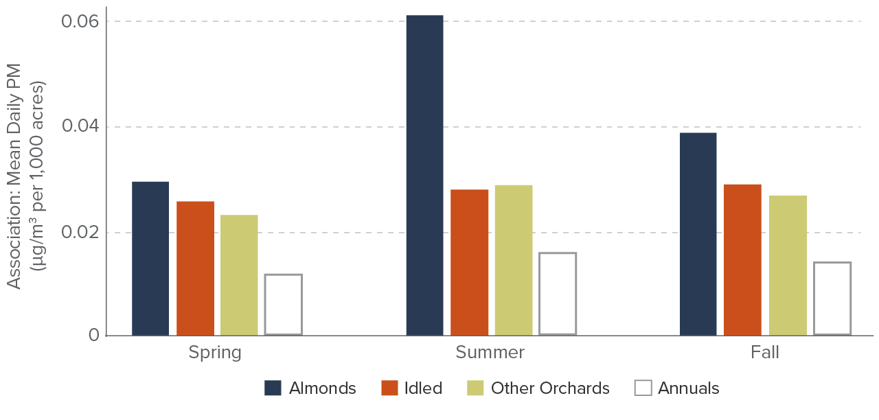
SOURCE: Developed by the PPIC Water Policy Center using data from NASA (particulate matter), USDA and Land IQ (land cover), and Cal Fire (wildfire burn acreage). For details, see Appendix A.
NOTES: Bars represent estimated relationships between land cover types and local particulate matter concentrations for each of three seasons. “Spring” includes March through May, “Summer” includes June through August, and “Fall” includes September through November. Annuals are shown with a hollow bar to indicate that no estimated relationship is statistically significant. Analysis is based on observed PM2.5 concentrations and land use from 2010–16. Winter months are not included because estimated associations were weak and typically not statistically significant.
Idled land is more closely associated with particulates than land with annual crops, and in seasons with strong winds (spring/fall) more so than most orchard crops as well. Nonetheless, idled land appears to be a less likely source of dust emissions than almond orchards, although this difference is only significant during late summer and fall.
Our analysis also included a “pasture” category, another potential outcome for formerly irrigated lands. This category contains a wide range of land management practices, including dedicated pasturelands (which may at times be irrigated) as well as unmanaged (and unirrigated) rangelands. Given the considerable uncertainty about what is on this land at different locations, we do not include the results in Figure 3. We note, however, that we find a significant association between this category and local particulate concentrations (see Appendix A for more details). This could be consistent with generally sparser vegetation and more regular disturbance from grazing that breaks up and pulverizes dry soils. Although many such areas throughout the southern portions of the valley are not irrigated, not managed actively to control dust, and opportunistically grazed when forage is available, we cannot document these conditions with available data. More work is needed to untangle how different types of pasture and rangeland might be associated with local dust emissions today—and how they might change in the future with careful management of groundcover and grazing.
The ultimate impact of land transitions on local air quality will depend on many factors, but a few guiding insights emerge from our analysis. First, during specific times of year, almond production’s impact on local particulate concentrations—and to a lesser extent other orchards’ impacts—may be substantial. This is broadly recognized by regulatory agencies; indeed, the SJVAPCD initiated its low-dust nut harvester program in response to stakeholder and industry acknowledgment of these localized impacts. Second, whether a transition from irrigated cropland increases the risk of heightened local particulate concentrations will depend on the initial crop being grown; risks appear greater where annual crops are taken out of production, but they also vary by time of year. Nonetheless, we caution that these results are preliminary and further exploration is warranted, especially regarding rangeland impacts. Ideally, this would be undertaken on the basis of improved monitoring of both land cover type and local particulate concentrations, which today represent key knowledge gaps.
Hotspots: Rural Communities, Soil Types, and Land Transitions
The scope and scale of emissions changes will depend on which crops transition out of irrigated production and how those lands are subsequently managed. The specific location of these lands—particularly in relation to rural communities—is equally important for understanding who could be exposed to new sources of dust. While we cannot forecast precisely where lands will come out of production, we can map the valley’s rural communities and assess their potential risk based on several factors.
The locations of many small communities in the valley (even those with just dozens or a few hundred inhabitants) can be identified by the location of their community water systems. These communities are often immediately adjacent to large expanses of what is now irrigated agriculture; they are exposed to dust from those operations today and could be potential hotspots for new impacts as conditions shift. To understand this, we mapped and compared their surrounding soil characteristics (using the Wind Erodibility Index (WEI) data published by Walkinshaw et al. (2021)) and baseline PM2.5 concentrations from 2010–16. The distance that dust may travel depends on particle size and windspeed, and some dust can potentially travel miles and stay suspended for days. We present results for our baseline approach, which considers soil types found on lands within 1.5 miles of each community. This is a “local” analysis that reflects likely travel distances of both small and large particles. Appendix A provides more details on our methods, and the left-hand panel of Figure 4 maps relative dust risk categories based on these factors.
Rural communities in the valley face different degrees of potential dust risk
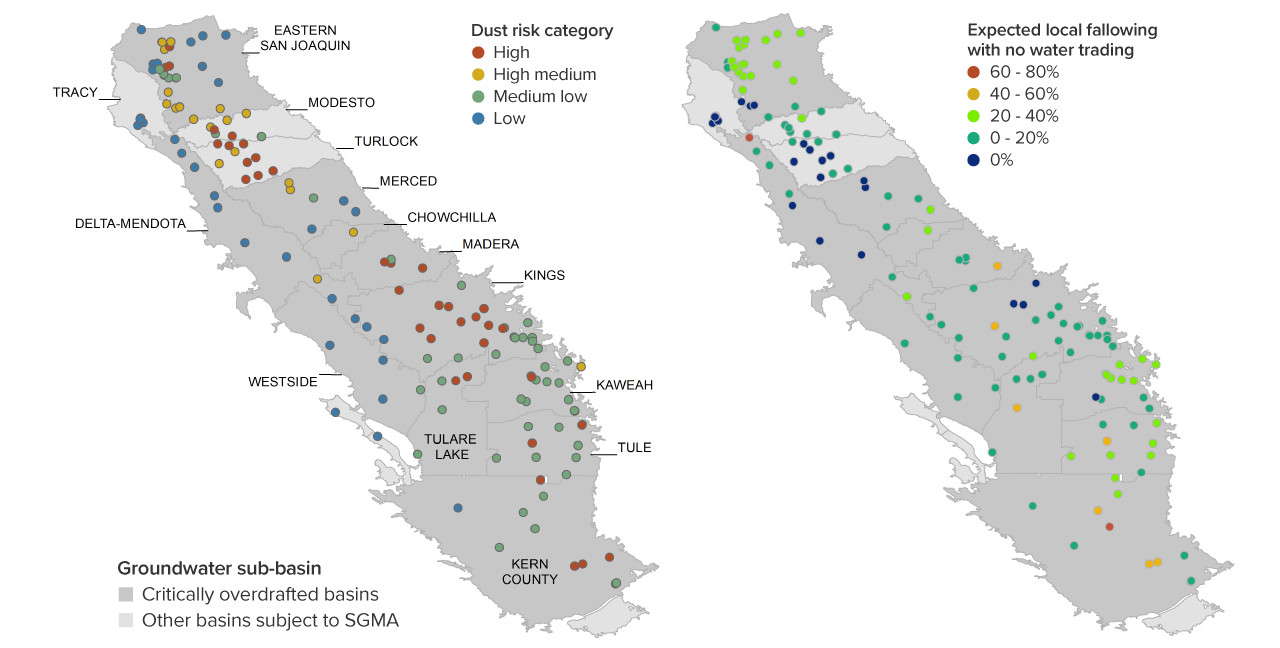
SOURCES: Developed by the PPIC Water Policy Center using data from the State Water Board (community water system locations), UC Davis (wind erodibility) and NASA (particulate matter), alongside preliminary PPIC estimates of land use change. See Appendix A for details.
NOTES: Plotted points reflect the locations of community water systems. Left-hand panel: Dust risk categories use the wind erodability index (WEI) and are as follows: high (WEI>86, ambient PM2.5>12 μg/m3 over 2010–16), high medium (WEI>86, PM2.5<12 μg/m3), medium low (WEI<86, PM2.5>12 μg/m3), and low (WEI<86, PM2.5<12 μg/m3). Right-hand panel: expected fallowing percentages are based on preliminary PPIC hydro-economic modeling scenarios that reflect full SGMA implementation without new valley water supplies and no trading across water district boundaries. Both panels: all values are calculated within 1.5-mile buffers, adjusted in the case of WEI and fallowing percentages to account for the footprint of the community; additional detail is available in Appendix A.
We break relative risk into four categories: the highest-risk areas are those that have highly erodible soils and baseline particulate matter concentrations exceeding the state annual average ambient air quality standard for PM2.5 (12 μg/m3), and the lowest have more stable soils and lower ambient concentrations. High and high-medium risk areas tend to be concentrated because they follow contiguous soil types. In particular, in some areas along the east side of the valley in Kings and Madera groundwater subbasins, as well as some along the central portion of the northern valley, rural communities are surrounded by relatively fine, erodible soils (see Figure 4, left panel). All else being equal, lands in these areas are more susceptible to erosion and, during high-wind events or intensive agricultural work, more dust. Accordingly, SGMA-induced land use changes that may result in riskier dust conditions—such as idling land and/or converting it for intensive grazing—may carry more tangible consequences for communities in these regions.
To illustrate how an extended analysis could forecast potential air quality impacts for the valley’s rural communities, the right-hand panel in Figure 4 presents preliminary estimates of where land fallowing could occur. These preliminary fallowing estimates are an extension of the work performed by Hanak et al. (2019) and reflect a SGMA implementation scenario with few additional valley water supplies and no trading across district boundaries (Escriva-Bou et al. forthcoming). Broadly speaking, the areas with the highest rate of expected fallowing show little overlap with high dust risk areas; while the more northern set of high dust risk communities show very little to any expected fallowing, those in Kings subbasin are typically expected to see up to 20 percent fallowing nearby. Areas that might see the most extensive fallowing (60–80%) are not co-located with erodible soils, although there are five communities with high dust risk that may see 40 percent to 60 percent fallowing, mainly in the southern valley. This example—while preliminary—shows how scenario modeling could help to inform targeted efforts to control dust in high-risk communities; future work, as part of our broader research project, will shed light on how water trading could shift this distribution of air quality risks (Escriva-Bou et al. forthcoming).
Maintaining Cover and Targeting Smart Investment
This report lays out the nature of the threat that large-scale land transitions may pose for air quality: upcoming decisions about how to manage the landscape will determine the extent of exposed and disturbed soils that could emerge as new dust sources. The valley’s increasingly arid environment presents an additional risk factor that can exacerbate dust issues by drying out the soil and making it more prone to wind erosion. Local and regional actors, alongside state and federal agencies, will need to identify and support solutions that can be effective today and under new, more arid conditions.
Mitigating Dust by Disrupting Wind
Where lands come out of regularly irrigated agricultural production, there are many options for addressing dust. At its core, though, this requires physically disrupting the wind processes that suspend particles (in the case of fugitive dust) and minimizing human disturbance of the land surface (especially where any sort of agricultural activity continues). Appendix B lays out a number of well-known on-farm interventions for tackling fugitive dust sources, along with cost estimates for their implementation. In some cases, applying artificial ground covers (such as mulch) or other activities such as surface roughening (accomplished using specific tilling techniques) may be appropriate. But the simplest and often most cost-effective interventions involve simply maintaining vegetative ground cover.
Yet maintaining vegetative cover while eliminating water use on these lands is a challenge. Transition of these lands is originally motivated by a lack of reliable water access, and increasing heat in the valley will further complicate growing conditions even for the hardiest of plants (see Footnote 5 for more on temperature changes). In addition, lessons from Antelope Valley and elsewhere suggest that establishing native plant species can be difficult on formerly farmed lands with excess soil nutrients, especially in early years.
The role of native groundwater allocations—allocation to landowners of the “native safe yield” of the groundwater basin, derived from precipitation and other natural aquifer inflows—may determine when and how vegetative management strategies are feasible. As outlined in PPIC’s companion report on water-limited agriculture (Peterson et al. 2022), application of even 4 inches of supplemental irrigation water can make the difference between failing to produce vegetative cover at all and a more-or-less reliable establishment of vegetation that could significantly reduce dust mobilization.
An additional difficulty involves managing weeds to reduce negative impacts on neighboring farms that may remain in production while avoiding excessive soil disturbance. A common weed management technique—disking or tilling of the soil—disturbs the soil surface and promotes conditions for fugitive dust generation. Lessons learned in eastern Washington about conservation tillage practices to reduce dust using specialized equipment may be transferrable in this case. Alternatively, targeted grazing efforts can be useful to help tamp down weed risks under certain conditions; indeed, the economic viability of many dryland or water-limited systems relies on grazing value. Nonetheless, similar to disking, grazing can disturb more fragile soils so much that significant issues with windblown dust arise. Where grazing becomes a component of viable, sustainable dryland management systems, deliberate and coordinated grazing plans will be necessary to avoid unreasonable local air quality impacts.
Some irrigated agricultural lands will convert to new uses that involve some artificial ground cover, such as solar energy fields or new peri-urban developments (Ayres et al. 2021a). In these cases, construction periods may see elevated dust generation. After construction, dust risks may be lower than the original agricultural practices or other non-irrigated alternatives, provided sufficient effort is undertaken to stabilize disturbed soils. Especially for solar development, this will depend on how land between solar panels is managed, including whether grazing is introduced between and underneath panels to manage vegetation. New solar developments are required to draft dedicated dust management plans, and the industry has learned important lessons about what vegetation types are most successful in valley solar developments. We take up solar development topics more broadly in a forthcoming report; for preliminary insights, see Ayres and Seymour (2022) and Rosser and De Leon (2022).
Who Can Take Proactive Measures?
Although state and federal agencies can provide valuable support, valley stakeholders and institutions will have the frontline responsibility for tracking and managing the potential air quality impacts of land transitions. Here we outline some of the key roles at different scales.
Local: Groundwater sustainability agencies
Groundwater sustainability agencies (GSAs) are the local entities responsible for SGMA implementation. Their planned projects and actions will influence which lands come out of production within their boundaries. This can include shaping the incentives surrounding land fallowing, for example by promoting or requiring certain management activities after land is removed from irrigated production.
Incorporating potential dust impacts into this decision-making process can help avoid future problems. One option for doing so is to support cover cropping on lands that are rotated out of production to conserve water. For example, in the Tule subbasin two GSAs that have adopted volumetric groundwater accounting and allocation systems are allowing landowners who cover crop to avoid “paying” for those crops’ evaporative water demands (Bardeen 2022b). This provides additional incentive to those who plant cover crops by increasing their credited water savings.
Furthermore, GSAs may well need to contend with requirements under the California Environmental Quality Act (CEQA) if their planned projects and actions to balance groundwater supply and demand result in negative local or regional spillovers. For instance, if groundwater allocation systems or targeted fallowing compensation programs must mitigate dust emissions under CEQA, GSAs will need to ensure their policies provide landowners with tools to manage these potential impacts. (Mitigation requirements are often a component of water trading projects that involve substantial land fallowing (Ayres et al. 2021b).) Working with county planning and environmental health offices—which also provide local oversight—can help to ensure coordination and successful program implementation. Entities familiar with effective practices, such as Resource Conservation Districts (RCDs), can support implementation.
Regional: San Joaquin Valley Air Pollution Control District
At the regional scale, the San Joaquin Valley APCD is a central implementation and support agency. As a regulator, it monitors and enforces required air quality management activities throughout the valley, but it also plays an important role in targeting and disbursing funding to support cost-effective dust mitigation efforts.
First, the regional air district has an important role to play in establishing responsibility for on-farm dust mitigation through its CMP Program, mentioned earlier in this report. This program identifies a set of on-farm practices that landowners can choose from to manage dust; many of these practices mirror those reported in Appendix B. Compliance with the proposed practices is enforced through on-site inspections performed by the district. The program is currently being evaluated for updates to further promote conservation tillage and otherwise more effectively reduce both PM10 and PM2.5 from agricultural lands. This represents an opportunity to further integrate considerations surrounding large-scale land transitions into district rulemaking.
When it comes to funding, the district’s programs to phase out agricultural burning and to replace older almond harvesting equipment can serve as models for future efforts to address land fallowing under SGMA. A recent decision to proceed with a near-complete phase-out of agricultural burning in the valley by 2025 will lead to important improvements in air quality; at the same time, some previously cost-effective alternatives for disposal of agricultural debris have become unavailable, most notably opportunities for biomass energy generation. The district was allocated $178 million in state funds to help identify and develop alternative uses for these agricultural materials, with some guidance on alternatives from the Air Resources Board (CARB 2021b).
As noted earlier, harvesting some nut crops—especially almonds—during the late summer and early fall can produce significant dust emissions. In collaboration with the Almond Board of California, the district has begun to administer a subsidy program that supports the adoption of improved, low-dust machinery throughout the valley. Subsidy rates range from 50 to 75 percent of new equipment costs, with the higher rates reserved for users within a seven-mile radius of Shafter, a Kern County community at special risk of dust impacts. To date, 164 old, high-polluting machines have been replaced with newer models designed to produce less dust; program expenditures totaled $13.7 million for these projects (Klassen 2022). This approach of scaling up mitigation support for high-risk areas can help improve program cost-effectiveness.
State agencies
In our assessment of dust mitigation case studies from elsewhere in California and the West, one consistent characteristic of successful programs was a sustained, reliable source of funding. This funding supported local efforts to implement measures at a large scale and compensated landowners for more targeted on-farm activities. State actors can act as important funding lynchpins for the valley, and some already are: the California Department of Conservation is currently managing $50 million to support multi-benefit land transitions with an express goal of avoiding negative impacts such as unreasonable dust generation. Yet the scale of upcoming land transitions will require more expansive and diverse funding sources to proactively address potential air quality impacts. Beyond the Department of Conservation, the Department of Food and Agriculture may be in a position to contribute funding for agricultural practices that reduce dust and help to manage transitions. In addition, the California Air Resources Board can provide oversight and monitoring, as well as funding to the regional air district to support cost-effective solutions for landowners.
Federal agencies
Federal agencies also played important roles in some of our dust mitigation case studies; in particular, the Natural Resources Conservation Service (NRCS) is a likely partner for GSAs, landowners, and other local stakeholders looking for funding to help manage lands. Landowners will be making decisions about where and when to fallow lands—in response to immediate drought or groundwater cutbacks—and looking for options to continue productive use of these lands. Funding under the Conservation Reserve Program (CRP) or other similar programs—little used in the valley at present—could deliver multiple public benefits. In some cases, GSAs can also avail themselves of different NRCS funding streams to plan for and achieve water use reductions at the district or agency scale, such as the Environmental Quality Incentives Program (EQIP) and the Regional Conservation Partnership Program (RCPP). We also note that, in the Antelope Valley case, funding through the NRCS Emergency Watershed Protection program supported dust mitigation, monitoring, and study. This program may also prove useful in cases where extensive land fallowing results in a high risk of public health impacts.
Recommendations
Effective responses to control dust in the face of large-scale land transitions will require action from all levels, including local landowners, regional air districts, and agencies well versed in funding and implementing dust management programs. These efforts will occur against a backdrop of valley particulate matter concentrations that now are increasing again following more than a decade of progress—and that could further worsen as the climate becomes warmer and drier. Integrating rural dust management programs into a broader plan to improve the region’s air quality should be a priority for state agencies like CARB. The following actions can help to prepare effectively for potential dust risks as the region implements SGMA:
- Invest in better understanding and monitoring rural dust. Currently, the monitoring of dust and other air pollutants in rural areas is limited. While monitoring is costly and fewer people are exposed to pollutants in these areas than in cities, SGMA and climate change potentially could increase emissions from landscape sources. Improving understanding of the problem could deliver large benefits, and this will require leadership at multiple levels.
- GSAs and local landowners should aim to understand risks and identify areas of particular concern. For instance, in locations with potentially exposed populations, proactive land management interventions could improve community resilience.
- Similarly, SJVAPCD, the regional air district, has an important role to play in identifying and tracking high-risk areas and communities as SGMA implementation proceeds.
- Since additional monitoring may be expensive, CARB and the US EPA can work with the regional air district to determine where such investments could yield the greatest benefit—both to understand acute risks and to help characterize rural air pollutant sources and dynamics.
- Clarify GSA and landowner roles in dust mitigation. Regional, state, and federal agencies with the authority to manage air quality have been around for years and have established responsibilities. In comparison, GSAs are newcomers—and they are responsible for managing land transitions that can affect local air quality. Better articulating their place in the planning process can improve coordination. In addition, landowner responsibilities for on-site dust mitigation, for example under air district CMP rules, could usefully be extended and updated to prepare for lands coming out of irrigated production in the coming decades.
- In seeking to formulate projects and actions that successfully integrate management of dust impacts, GSAs should be sure to interface early and often with county authorities and tailor programs to applicable county requirements.
- The regional air district’s update of its Rule 4550 and CMP Program presents an opportunity to incorporate land transitions concerns. Current rules identify land fallowing as a way to reduce emissions from agricultural operations. The evaluation process considers promotion of conservation tillage practices to reduce dust from seasonally fallowed and tilled agricultural land. Identifying and articulating best practices on lands that may exit irrigated production for longer periods and potentially transition to new uses will be important as well; promotion and support of cover cropping and water-limited farming strategies could be usefully expanded.
- State agencies and the legislature could provide additional clarity on GSA responsibilities for addressing the potential air quality impacts of SGMA fallowing programs. Right now, GSAs are focused primarily on designing measures to balance groundwater supply with demand. If they must take on additional responsibility for managing dust impacts under CEQA or other laws, they will need to start planning for that today and access funding to get the job done.
- Leverage existing funding programs, and develop new sources where necessary. This report presents several dust management efforts from elsewhere in California and the American West; in each, a dedicated funding source was foundational to the effort’s success. In some cases, funding at the GSA scale may be effective, while in others direct payments to landowners may be necessary to support on-farm dust mitigation. Support in the early years of implementation can be particularly important to help pilot efforts and find the most cost-effective approaches.
- GSAs can help to connect individual landowners with available funding streams—including their own programs and others. Stakeholders in our workshops explained that accessing existing funding sources that support on-farm dust mitigation techniques (e.g., conservation grant programs) can be complicated for landowners.
- The regional air district is experienced in developing and executing funding programs. Funding efforts modeled after the low-dust harvester replacement program can provide broad benefits and leverage scientific understanding to improve the cost-effectiveness of disbursed funds.
- New state initiatives will be important for providing sustained funding for dust mitigation. Expansion of the new multi-benefit land repurposing funding available through the Department of Conservation would help additional areas address the impacts of land transitions.
- Finally, the federal government can support these efforts by continuing to integrate specific dust management concerns in its established NRCS programs in the valley. It can also play an important role as a “funder of last resort” should local planning falter and persistent, acute dust problems develop. It was precisely this sort of funding (under an NRCS Emergency Watershed Protection grant) that allowed a group including the air district and extension researchers to address the severe wind erosion issues that developed in Antelope Valley following agricultural land retirement.
- Promote new, innovative solutions that fit local and valley needs. The scale of this land transition will require a concerted effort to develop approaches that fit local conditions and take advantage of coordination opportunities across the valley. The importance of identifying high-risk areas regularly came up in our discussions with stakeholders. Our analysis suggests that rural communities do not all face similar air quality risks from a transition to reduced water use on these lands—and that such transitions could actually reduce dust exposure during certain times of year in areas with extensive orchards.
- Local landowners, GSAs, and counties should identify important hotspots for dust emissions. When fallowing near a community is inevitable, and maintaining vegetative land cover is not feasible, they could develop plans to “harden” surrounding areas to mitigate adverse impacts, much as landowners might harden areas around their homes to reduce wildfire risk. Such interventions could be expensive; early efforts to acquire funding can yield dividends.
- The regional air district should also look for synergies between continued agricultural production and air quality solutions. Supporting dryland or water-limited production on some lands could help maintain vegetative cover. Spreading mulch from woody debris has reduced dust emissions at very low cost in some dry environments in California. In the valley, orchard trees have often been burned for disposal, but as burning is phased out chips or mulch from dead trees could serve this purpose. While landowners may sometimes prefer to recycle these residues into orchard grounds to provide agronomic benefits, in some cases mulch may be appropriate for dust suppression; in addition, other orchard residues such as almond shells can effectively be used to suppress dust.
Conclusion
The future of economic and social wellbeing in the San Joaquin Valley depends on better managing groundwater. Achieving the goals sets forth by SGMA will be no small feat, and it will entail costly adjustments over the next two decades. To avoid significant public health and environmental risks during large-scale farmland transitions, it will be important to build a better understanding of landscape-based dust emissions. Despite progress in the 2000s, the valley faces increasing particulate matter concentrations today—and the changing climate is intensifying risks from sources like wildfire and dry, mobile soils. Moreover, increased dust emissions likely will affect low-income, rural communities within agricultural areas first and foremost.
While the ultimate impact of land transitions will depend on which crops are removed from production and how the land is subsequently managed, they could be large. Coordinated mitigation responses can reduce this risk. Proactive management, with improved monitoring of dust emissions and early identification of at-risk communities, can help to direct efforts where they are needed most.
Experiences with land fallowing and retirement elsewhere in California and the West deliver some important lessons about the need for comprehensive monitoring. They also highlight opportunities and challenges in establishing robust vegetative cover and provide examples for other important on-farm practices. While further clarifying local agency and landowner responsibilities for managing dust is an important first step in preparing for the coming changes, sustained funding is a must: it can enable large-scale, coordinated dust control initiatives or compensate landowners for on-farm measures. Finding and sustaining this funding to support low-impact land repurposing in the valley is a key challenge that local groundwater agencies, state agencies, and federal land management programs can collectively tackle.
Topics
Drought Health & Safety Net San Joaquin Valley Water Supply Water, Land & AirLearn More
Commentary: Can San Joaquin Valley Agriculture Survive with Less Irrigation? Here Are Ways To Do It
Commentary: Drought Requires New Strategies for Managing Cropland
Commentary: San Joaquin Valley’s Next Big Air Pollution Threat—Blowing Dust from Fallowed Farmland
Dangers Lurk in the San Joaquin Valley’s Dust
Exploring the Potential for Water-Limited Agriculture in the San Joaquin Valley